
Technical data

Chapter 1 Introduction
12
Using AutoCAD Land Development
Desktop to Complete a Project
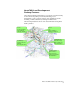
The process of land development is highly iterative. AutoCAD Land
Development Desktop makes it easy to add new data at any step of the
project. A typical project begins with capturing data in the field. Back
in the office, you can use AutoCAD Land Development Desktop to set
up an organizational structure for the project, and then you can input
the data into the project and drawing.
After you input the raw data, you can define and transform it so that
the definitions are saved to external databases. You can then build a
surface that represents the terrain of the job site. You can analyze data
in a variety of ways to determine if the site is sufficient. If so, you can
create design documents by labeling and plotting out the drawings. If
not, you can input more data, edit existing data, and then recompile
the surface data.
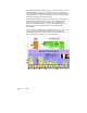
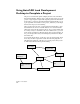
You can edit data all along, at each step. You can output results, input
more data, and then output new results. The following diagram is a
simplified representation of the flow of a typical project that you can
do with AutoCAD Land Development Desktop.
Collect Data
Organize Data
Define/Transform
Data
Build Surface Model
Output and Evaluate
Data
Create Design
Documents
Edit Data
Input Data