
Technical data


Building Surfaces
189
To build a watershed model (
continued
)
Steps
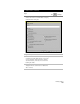
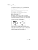
Use
to look up
7
Use the options in the upper part of the dialog box
to control the appearance of the watershed
boundaries that are imported.
Select Fill With Solids to import solid fill areas, or
leave this check box unselected to import polyline
boundaries.
When you import polyline boundaries, you may
also want to select the Display ID Numbers check
box to insert the watersheds’ ID numbers within
the polyline boundaries.
8
Select options for layers, and click OK to draw the
boundaries on the surface.
TIP Make the colors of each of these layers
different so you can easily distinguish
what type of watershed is outlined.
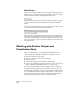
9
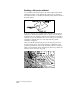
To show how a drop of water would flow across
the surface, you can trace that path in your
drawing by choosing the Water Drop command
from the Terrain ➤ Surface Utilities menu.
Select a point on the surface, and the Water Drop
command draws a polyline that represents the
path that water would take as it flows from that
point toward the drain target.
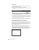
Draw Water Drop Paths on
the Current Surface