
Technical data
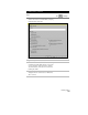


Building Surfaces
187
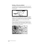
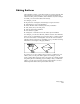
Watershed subareas can have different types of drain targets. Drain
targets of some subareas can be based on a boundary point, the point
where the channel of water would drain off the surface. Drain targets
of other subareas can be depression areas where the water will flow.
Key Concepts
■
If the Watershed command determines that water from one TIN
surface triangle could flow into more than one watershed subarea,
then it splits the TIN triangle to make two triangles. This ensures
that each watershed consists of complete triangles, and that the
boundary of each watershed consists solely of TIN edges.
■
If you use contour data to build the surface, then be sure to use the
Minimize flat triangles resulting from contour data option in the
Build Surface dialog box to minimize the number of flat triangles
that make up the TIN surface, and thus make the watershed model
more accurate.
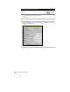
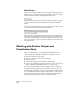
To build a watershed model
Steps
Use
to look up
1
From the Terrain menu, choose Terrain Model
Explorer to display the Terrain Model Explorer
dialog box.
Create and build a surface model if one does not
exist.
Build a Surface
2
Open the surface folder to display the data tree.
3
Right-click the Watershed icon and choose
Calculate Watershed.
Overview of Creating
Watershed Models