
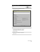
Technical data


Chapter 5 Working with Surfaces
186
Building a Watershed Model
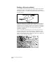
You can build a watershed model of the current surface either while
building the surface or after building the surface. The program uses
the surface TIN lines to calculate the channels where water would flow
along the surface.
From these channels, the command then determines the watershed
subareas, also known as catchment areas or regions. You can import
boundaries into the drawing to delineate and number the watershed
subareas, and you can determine the color of each type of watershed
boundary by changing the color of the layer that the polyline
boundary is assigned to.
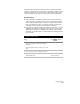
After you build the watershed model, you can draw slope arrows to
show the surface slopes, and use the Waterdrop command to draw
polyline representations of the path that water would flow along the
surface toward channels. If the channel splits, then new polylines are
drawn to follow each water drop path.