
Technical data

Building Surfaces
183
Building Surfaces
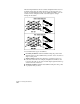
After you choose which information to include in a surface, you
can build the surface. When you build a surface, all the surface data
is processed and the program calculates the surface triangulation.
The triangulation is calculated by combining the breakline,
contour, and boundary data with the surface point data and
interpolating the results.
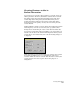
Specifying Data for Surfaces
Not all data in your drawing and project must be used in a surface
model. You can choose which points, contours, breaklines, and
boundaries to include. Everything that you add to the surface folder in
the Terrain Model Explorer can be used in a surface, but you can
exclude certain data from build to build to examine different results.
Key Concepts
■
You can have an unlimited number of surfaces in a project or
drawing.
■
Surfaces are stored in the c:\Land Projects R2\<project name>\dtm
folder.
■
You can access surfaces simultaneously across a network. The first
user who opens the surface has read/write access to it. All other
users have read-only access.