
Technical data

Creating Surface Data
181
Creating Contours to Use in
Surface Generation
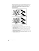
You can use vector contours, either polylines or contour objects, in
surface generation. However, information obtained from a contour
map differs greatly from data taken randomly in the field. Since
contour map data is interpolated, the information may be less
accurate than direct field data. The accuracy of the final surface
model depends on the quality of both your contour map and the
contour interval.
Unlike breaklines, which you create directly from within the Terrain
Model Explorer, contours (as contour objects or polylines) must
already exist in the drawing in order to select them as surface data.
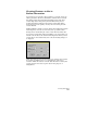
You can use contour data either as breaklines or as points when you
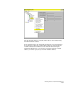
add the contour data to the Terrain Model Explorer. When you add
contour data to the surface folder, the Contour Weeding dialog box
is displayed.
When the Create as contour data check box is selected, the contours
are treated as breakline data, so no triangulation occurs across
contours. When the Create as contour data check box is cleared, the
contour vertices are treated as point data for the purposes of
triangulation.