
Technical data

Creating Surface Data
179
When you add the surface data into the Terrain Model Explorer, you
are determining which objects to include in the current build of the
surface. These objects can be point groups, point files, breaklines,
contours, and boundaries.
Key Concepts
■
To create or import point data you must either have point groups
defined and points in the COGO point database, or an external
point file to import.
■
When you import a point file into the Terrain Model Explorer, the
point data is not added to the point database. The data is used
exclusively for building the surface.
■
To add contour data to a surface, you must have contour objects or
polylines in your drawing.
■
To add breaklines, you must use the commands on the Breaklines
shortcut menu in the Terrain Model Explorer.
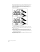
Creating Breaklines to Use in
Surface Generation
Breaklines are constraint lines that represent abrupt changes in a
surface such as retaining walls, stream banks, and curbs; or objects
with known elevations, such as contours. You can use breaklines to
prevent surface triangulation from occurring across these objects.
Breaklines can be either “destructive” or “non-destructive.” All the
Breakline commands create destructive breaklines. A destructive
breakline prevents TIN lines from crossing the breakline. This is
essential if the breakline represents a constant elevation—you do not
want to interpolate elevations across such a breakline. The breakline
also forces retriangulation of the surface based on the breakline
vertices.