
Technical data


Chapter 5 Working with Surfaces
176
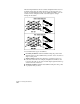
Surface Accuracy
When gathering data for the surface model, you need to be very
thorough so that the model you create is accurate enough for your
intended purpose.
At the beginning of a project, you can make a quick surface model by
digitizing a contour map of the existing site, and create the surface
model based on the contours only. If the project is more advanced,
and you already have survey data, then you can use the point data
from that survey to create a more accurate surface model.
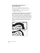
If you do not have enough surface data, then the surface elevations
may not be interpolated correctly. By being thorough, you can better
ensure that the surface output—such as contours, volumes, watershed
models, profiles, and cross sections—is as accurate as possible.
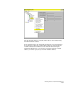
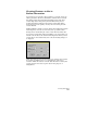
Working with the Terrain Model Explorer
The Terrain Model Explorer consolidates all the surface creation and
management features in one place. You can use the Terrain Model
Explorer to create, open, build, and view surfaces.
The Terrain Model Explorer contains a Terrain and a Volume folder.
To create a new surface, right-click the Terrain folder and select Create
New Surface. When you create a surface, a surface folder is created
below the Terrain folder. Open this folder to use the surface data
icons. You can right-click the folders and icons in the left pane of the
Terrain Model Explorer to access commands.