
Technical data

Chapter 5 Working with Surfaces
174
Introduction
After you have input data into a project, you can create a surface
model from that data. A surface model is a three-dimensional
geometric representation of the surface of an area of land. Surface
models in AutoCAD Land Development Desktop are made up of
triangles, which are created when AutoCAD Land Development
Desktop connects the points that make up the surface data.
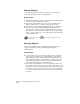
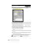
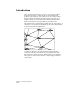
The triangles form a “triangulated irregular network” (TIN) surface. A
“TIN line” is one of the lines that makes up the surface triangulation,
as shown in the following illustration.
To create the TIN lines, AutoCAD Land Development Desktop
connects the surface points that are closest together. These TIN
lines interpolate surface elevations, filling in the gaps for which no
survey data or contour data is known, to create an approximation
of the surface.