
Technical data

173
5
Working with Surfaces
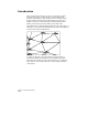
You can use points, contours, breaklines, and
boundaries to generate a model of the earth’s surface
for a particular parcel of land. From this model, you
can create contours and sections, and by comparing
two models, you can calculate volumes.
In this chapter
■
Working with the
Terrain Model Explorer
■
Creating Surface Data
■
Building Surfaces
■
Editing Surfaces
■
Working with
Surface Output and
Visualization Tools