
Technical data


Digitizing
159
For example, if you have a raster image of contour lines, then you can
insert the image into the drawing (at world coordinates and correct
scale) and then use the Digitize Contours command on the
Terrain ➤ Contour Utilities menu to trace the raster image on screen.
If you have a paper contour map, then you can use a tablet and a
digitizer puck to trace the contours, creating polylines on screen that
you can later turn in to contour objects that you can use when
building an existing ground surface.
Choosing a Digitizing Method
■
For contours, you can use the Digitize Contours command. This
command draws straight line segments only. You can assign an
elevation to the contour as you digitize it, and you can make this
elevation relative to other contours you draw. For more
information, see “Digitize Contours” in the online Help.
■
You can digitize by using polylines, lines, and arcs. For more
information, see “Creating Objects” in the online Help.
■
You can set up AutoCAD Land Development Desktop to use a
tablet to digitize. For more information, see “About Digitizing and
Importing” in the online Help.
■
Autodesk CAD Overlay
®
has two advanced digitizing tools that
you can use to digitize raster images. One method employs
snapping tools you can use to snap to existing raster lines. The
other follows lines automatically until it reaches a stopping point.
For more information about CAD Overlay, contact your
authorized Autodesk dealer.
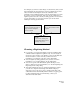
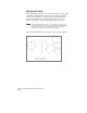
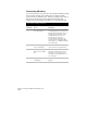
Result
Vectors in the drawing that
AutoCAD Land Development
Desktop can process
Raster
Image
Inserted into drawing and traced
using commands like Digitize
Contours or PLINE
Paper
Document
Taped to tablet and traced with
a digitizer