
Technical data

Chapter 3 Working with COGO Points
120
To calculate State Plane coordinates from GPS data (
continued
)
Steps
Use
to look up
8
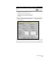
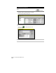
Into the Reference Point section, type the grid
northing and grid easting coordinates for the first
point that you calculated with the Geodetic
Calculator.
Type the local northing and easting coordinates
for the same point. Or, if you already placed that
point in your drawing, you can click the Reference
Point button and select the point from your
drawing. You can also type the point number to
retrieve the local northing and easting coordinates.
9
Repeat step 8 using the second set of grid
northing and easting coordinates, but enter the
information in the Rotation Point section.
10
Click OK to apply the transformation settings.
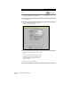
11
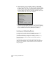
From the Points menu choose Point
Utilities ➤ Geodetic Calculator.
Now you can use the Geodetic Calculator to query
the grid northing/easting and latitude/longitude
of any point in your survey.
12
Type the local northing and easting coordinates,
and the grid coordinates and latitude/longitude
are calculated automatically.
NOTE For more information about performing zone conversions, see
“Performing Zone Conversions Using AutoCAD Map” in Chapter 8,
“AutoCAD Map and AutoCAD Land Development Desktop.”