
Technical data

Working with Points
119
To calculate State Plane coordinates from GPS data (
continued
)
Steps
Use
to look up
5
Type the latitude and longitude of the second
point that you collected and make a note of the
grid northing and grid easting coordinates.
You can now use these grid northing and easting
coordinates to set the transformation settings for
the drawing.
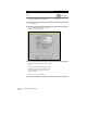
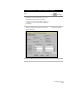
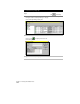
6
From the Projects menu choose Transformation
Settings to display the Geodetic Transformation
Settings dialog box.
Change the Geodetic Zone
Transformation Settings
7
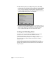
Select the Apply Transform Settings check box.