
Technical data

Chapter 3 Working with COGO Points
118
To calculate State Plane coordinates from GPS data
Steps
Use
to look up
1
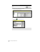
From the Projects menu, choose
Drawing Setup
to display the Drawing Setup dialog box.
Change the Current Zone for
a Drawing
2
Click the Zone tab and select the current zone
for the drawing.
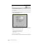
3
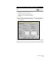
From the Points menu choose Point
Utilities ➤ Geodetic Calculator to display the
Geodetic Calculator dialog box.
4
Type the latitude and longitude of the first point
that you observed with your GPS into the dialog
box.
The calculator automatically displays the grid
northing and grid easting coordinates for the
point, related to the current zone that you
selected in step 2.
Make a note of these coordinates.
Use the Geodetic Calculator