
Technical data

Working with Points
117
Key Concepts
■
The State Plane coordinates are expressed as grid northing and grid
easting coordinates.
■
Local northing and local easting coordinates, the assumed
coordinates, are equivalent to the COGO point coordinates in the
point database.
■
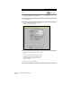
The Geodetic Calculator supplies “missing” information related to
the current zone. For example, if you know the latitude and
longitude of a point, then you can type this information into the
calculator to compute the grid northing/easting coordinates. You
can then use this information to set the Transformation Settings for
the whole drawing.
■
After you set the Transformation Settings for a drawing, you can
enter the local northing/easting coordinates into the Geodetic
Calculator to compute either the grid coordinates or latitude and
longitude of any point.
■
You can create and edit all data used to create various projections.
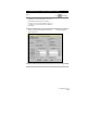
Calculating State Plane Coordinates from a
Known Latitude and Longitude
You can use the Geodetic Calculator to relate local northing and
easting coordinates to a State Plane coordinate system by using a
known latitude and longitude that you collect using a Global
Positioning System (GPS) receiver.
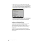
After you calculate the grid coordinates, you can set the
transformation settings for the whole drawing. This lets you
calculate the grid coordinates or latitude and longitude of any
point in your survey.
The following task supposes that you took two separate GPS
latitude/longitude readings on two different points, and also recorded
these two points’ local northing and easting readings.