
Technical data

Chapter 1 Introduction
4
Who Should Use AutoCAD Land
Development Desktop?
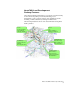
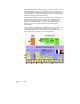
The land development industry is very broad. It includes all
professionals who manage, analyze, or alter the land, specifically
surveyors, civil engineers, land planners, environmental designers,
forest managers, hydrologists, GIS analysts, landscape architects,
resource managers, and more.
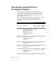
Land development professionals may require different tools to do their
jobs. The following table shows these requirements and which
programs in Land Development Solutions suite meet these
requirements.
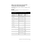
Requirements of land development professionals
Professional Requirements Land
Desktop
Autodesk
Survey
Autodesk
Civil
Design
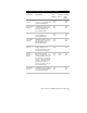
Land Planner The ability to view data, terrain
models, plans, maps, images,
and drawings. The ability to do
analysis through queries and
topologies to determine land
use, development trends, and
buildable areas.
Drafter/CAD
Technician
More than what is in standard
AutoCAD in order to draft
directly from the project data
created by other team
members.
Surveyor Land Desktop plus the data
input and collection options in
Autodesk Survey.
Surveying
Technician
Land Desktop plus the data
input and collection options in
Autodesk Survey.
Site Designer Land Desktop and the grading,
hydrology, and piping
functionality in Autodesk
Civil Design.