
Technical data

Chapter 3 Working with COGO Points
112
Exporting Points
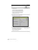
To export points from the COGO point database to an ASCII text file,
you must set up an import/export format. The export format should
reflect the point information that you want to export. For example,
you can set up an export format to export point number, northing
and easting, elevation, description, and latitude and longitude to an
ASCII text file.
You can export points from the project point database in order to
either create reports of the project point data or to upload to a data
collector.
Selecting Points by Using Point Filters
When you are using any AutoCAD Land Development Desktop
command that prompts you to select a point in the drawing, you can
■
Select any point on the screen by using object snaps or by typing
X,Y coordinates.
■
Use an AutoCAD Land Development Desktop point filter.
Point filters make it easy for you to accurately retrieve coordinate
points from the point database or to select points from the drawing.
Point filters are simply a letter, preceded by a period, that you can
type at any “Select Points” prompt. For more information, see “Using
Point Filters to Select Points” in the online Help.
■
You can type .P and then type a specific point number.
■
You can type .G and then select the point in the drawing.
■
You can type .N and then type the point’s northing and
easting coordinates.
For example, you could use the .G graphical selection filter to pick any
part of a point object on screen. This retrieves the exact coordinates of
the point object from the point database.