
Technical data

What Is AutoCAD Land Development Desktop?
3
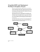
AutoCAD Land Development
Desktop Features
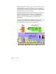
AutoCAD Land Development Desktop provides the core functionality
for the land development professional, including project
management, points, geometry creation, plan alignments, terrain
modeling, volumes calculations, labeling, and much more.
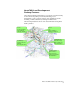
The following illustration shows some AutoCAD Land Development
Desktop features.
Parcels
Size
Define and Label
Manage and Report
Plan Alignments
Create Geometry
Define Alignments
Offset and Station
Terrain Modeling
Create Surfaces
Create Contours
Analysis and Volumes
3D Visualization
Site Drafting
Symbols and Lines
Labeling
Geometry Creation
Points
Create and Query
Import/Export
Manage and Edit