
Technical data

Chapter 3 Working with COGO Points
96
Introduction
Points that identify locations, by using northing, easting, and
elevation, are the basis of almost every land development project. The
more accurate and thorough your point data is, the more accurate
anything that you generate from the points are, such as surfaces,
geometry, and so on.
Points that AutoCAD Land Development Desktop creates are called
COGO points. COGO stands for “Coordinate Geometry.” COGO
points are stored in an external database, and are organized by their
point numbers. COGO points have extended entity data that is
associated with the points. This data includes point number, point
name, description, and elevation. All but the point number are
optional.
COGO point data is stored in an external database file called
points.mdb. All drawings in the project reference this database.
Because all the project points are stored externally, you can reference
the points without them being drafted in the drawing, and multiple
people can access the point data on a network.
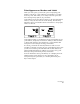
To add points to the point database, you can create points in the
drawing, import ASCII files, import data from a Microsoft
Access
database file, or download from a data collector.
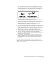
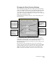
The following diagram illustrates several ways to add points
to a project.
The Points menu contains most of the point commands that you use
to set point settings, add points to your project, and edit points in
AutoCAD Land Development Desktop.
Create points
within a
drawing/project
Import ASCII
point files
Download survey
data from a Data
Collector to create
field book or ASCII
files to import
points.mdb