
User Guide
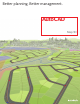


Use Display Manager to stylize CAD and spatial data to produce quality maps. Then more quickly publish them as
georeferenced DWF™ files, map books, or paper plots. Data used in image ©IGN 2007
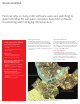
Improving Infrastructure
AutoCAD
®
Map D software can provide direct
access to data needed for infrastructure planning,
design, and management activities. AutoCAD Map
D helps professionals working on transportation,
land development, water, and power projects to
more easily create, manage, and analyze design, GIS,
and asset data.
Find out why so many CAD software users are switching to
AutoCAD Map D software—A better AutoCAD software
for planning and managing infrastructure.
Access Granted
Built on AutoCAD Software
Because Map D software is built on AutoCAD
®
technology, organizations can take full advantage of
the extensive CAD-trained workforce to create, edit,
and maintain geospatial data. And by using familiar,
precision CAD tools, team members can make the
most of their AutoCAD expertise.
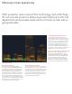
More Informed Design
AutoCAD Map D helps organizations to create
better designs. Map D can provide access to data
needed for planning, design, and asset management
activities, making it easier for team members to
evaluate existing conditions and perform corridor,
network, and site analysis.
Used Around the World
Utilities and Telecommunications
• LosAngelesDepartmentofWater
and Power
• TokyoElectricPowerServicesCo.,Ltd
• Comcast Cable
Transportation
• KoreanExpresswayCorporation
• LosAngelesInternationalAirport
• MassachusettsPortAuthority
Natural Resources—Mining, Petroleum,
Environmental Engineering and
Management, Water Resources
• PetrobrasTransporteS.A.–Transpetro
• KARICO
• RushmoorBoroughCouncil,England
Government—Public Works, Land
Planning, and Management
• SanFranciscoDepartmentofPublic
Works Bureau of Engineering
• RehabilitationandReconstructionBoard,
Indonesia
• CityofFribourg,Switzerland