
User`s guide
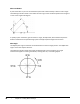
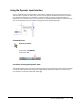
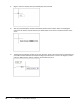
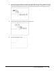
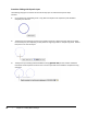
Table Of Contents
- Introduction
- Chapter 1: Taking the AutoCAD Tour
- Chapter 2: Creating Basic Drawings
- Chapter 3: Manipulating Objects
- Lesson: Selecting Objects in the Drawing
- Lesson: Changing an Object's Position
- Lesson: Creating New Objects from Existing Objects
- Lesson: Changing the Angle of an Object's Position
- Lesson: Creating a Mirror Image of Existing Objects
- Lesson: Creating Object Patterns
- Lesson: Changing an Object's Size
- Challenge Exercise: Grips
- Challenge Exercise: Architectural
- Challenge Exercise: Mechanical
- Chapter Summary
- Chapter 4: Drawing Organization and Inquiry Commands
- Chapter 5: Altering Objects
- Lesson: Trimming and Extending Objects to Defined Boundaries
- Lesson: Creating Parallel and Offset Geometry
- Lesson: Joining Objects
- Lesson: Breaking an Object into Two Objects
- Lesson: Applying a Radius Corner to Two Objects
- Lesson: Creating an Angled Corner Between Two Objects
- Lesson: Changing Part of an Object's Shape
- Challenge Exercise: Architectural
- Challenge Exercise: Mechanical
- Chapter Summary

Lesson: Inputting Data ■ 47
About the Coordinate System
Every object you draw is placed in either the world coordinate system (WCS) or a user coordinate
system (UCS). When you create 2D geometry, data input is ultimately passed to the software in the
form of Cartesian (x,y) or polar coordinates (distance, angle). You can either manually enter these
coordinates or infer them by picking a point in the drawing window.
Cartesian Coordinate System
Every object you draw is placed in either the World Coordinate System (WCS) or a User Coordinate
System (UCS). When you create 2D geometry, data input is ultimately passed to the software in the
form of Cartesian (x,y) or polar coordinates (distance, angle). You can either manually enter these
coordinates or infer them by picking a point in the drawing window.
The Cartesian coordinate system is used to determine points in space that are a specified distance
from a set of perpendicular axes that intersect at the origin of the system.
In the World coordinate system, the X axis represents the horizontal direction, the Y axis represents
the vertical direction and the origin is located at 0,0. Positive X moves to the right, positive Y moves up,
and the Z axis moves in the positive direction directly towards you, the viewer.
Note that for this course we will only be concerned with the X & Y coordinates since we are working in
2D. The Z coordinate will always be zero and need not be specified.
The following image illustrates a line drawn from the origin of the coordinate system 0,0 with its
endpoint at the coordinate 4,6.
To specify a Cartesian coordinate, type the X and Y coordinates and press ENTER. Example: 4,5 where
X is equal to the distance from the origin along the X axis and Y is equal to the distance from the origin
along the Y axis.