
Technical information

74 | Chapter 4 Working with Surfaces
Editing Surfaces
After building a surface, you should evaluate its accuracy. Did the TIN lines
generate as expected? If not, you can go back and define new surface data like
points, breaklines, and boundaries. Or, if the changes are small, you can edit
the surface TIN directly.
For example, you can
■ Flip the faces of triangles to match ridges or depression areas.
■ Add TIN lines to force retriangulation.
■ Delete TIN lines that extend beyond survey boundaries.
■ Add, delete, move, and edit points.
■ Add breaklines.
■ Paste surfaces together.
■ Change the overall elevation of the surface by an increment.
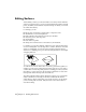
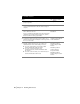
For example, you can add a TIN line, which forces the other TIN lines that it
crosses to retriangulate. You can add points to a surface, which also forces the
surface to retriangulate. You can also trim out surface TIN lines that are
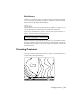
drawn across a building pad or pond. The following illustration is an example
of flipping TIN faces.
To combine two or more surfaces into one surface, paste them together. For
example, you can create a surface that represents only part of a site, such as
a surface that contains the grading data for a building pad. After you build
this surface, you can paste it into the existing ground surface to create a fin-
ished ground surface that represents the entire site.
The surface TIN lines must be in the drawing in order for you to use the Edit
Surface commands. Use the Import 3D Lines command from the Edit
Surface menu to import surface lines you can edit. Be sure to set the surface
you are working with as current. Only the data for the current surface is
used when editing.