
Technical information

Creating Finished Ground Data for Surfaces | 73
Creating Finished Ground Data for Surfaces
AutoCAD Land Desktop has many commands that you can use for creating
finished ground data to use for surfaces. The following table summarizes a
few of the point, 3D polyline, and contour grading methods you can use for
creating finished ground surface data.
When you are ready to create the surface based on this grading data, you
must add the surface data to the surface folder in Terrain Model Explorer. The
following table shows how to process each type of grading data.
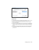
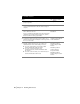
Methods for creating finished ground surface data
Point Grading 3D Polyline Grading Contour Grading
Create points at the vertices
of a 3D polyline
Create 3D polylines by
specifying an elevation or a
slope
Create contours along a
proposed slope or grade
Create points where two
slopes or grades intersect
Fillet 3D polylines Create multiple offsets of a
contour at a specified interval
and grade until a specified
distance or elevation is reached
Interpolate points between
two selected points, based on
total distance
Offset existing polylines in
the drawing and apply
elevational changes to the
offset polylines
Copy existing contours that
you can update with new
grading data
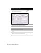
Processing different types of surface data
Object How to process as surface data
2D Polylines Select as contours
3D Polylines Select as breaklines or as contours
Points Select as points or point groups