
Technical information


Creating Surface Data | 69
You can use contour data either as breaklines or as points when you add the
contour data to the Terrain Model Explorer. When you add contour data to
the surface folder, the Contour Weeding dialog box is displayed.
When the Create as Contour Data check box is selected, the contours are
treated as breakline data, so no triangulation occurs across contours. When
the Create as Contour Data check box is cleared, the contour vertices are
treated as point data for the purposes of triangulation.
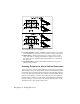
Creating Boundaries to Use in
Surface Generation
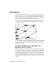
Boundaries can help eliminate certain surface editing tasks.
■ Boundaries control how the surface TIN lines extend to the outer limits of
a surface.
■ Boundaries hide internal areas of a surface.
For example, if a pond exists on the surface, you can either build the surface
and then delete the triangulation lines that cross the pond, or you can create
a boundary around the pond before building the surface so that the area of
the pond is hidden. The same applies to outer surface boundary lines. You
can either delete the TIN lines that extend beyond the survey limits after you
build the surface, or you can create a boundary around the survey limits
before building the surface.