
Technical information


66 | Chapter 4 Working with Surfaces
Use the shortcut menus to add the surface data to the surface folder, and then
build the surface.
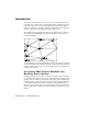
The Volume folder in the left pane of the Terrain Model Explorer contains
information about grid and composite volume surfaces that are created from
the volume calculations commands on the Terrain menu. Use the Terrain
Model Explorer to view properties about the volume surfaces, as well as open,
close, and view volume surfaces.
You can keep the Terrain Model Explorer open while you use other com-
mands. Use the buttons in the upper-right corner of the dialog box to
minimize, maximize, and close the Terrain Model Explorer.
Creating Surface Data
Before you can build a surface, you must create surface data in the Terrain
Model Explorer by using the shortcut menu commands, such as Add Point
Group.
When you add the surface data into the Terrain Model Explorer, you are
determining the objects to include in the surface. These objects can be point
groups, point files, points, DEM files, breaklines, contours, and boundaries.