
Technical information


64 | Chapter 4 Working with Surfaces
Introduction
After you have entered data into a project, you can create a surface model
from that data. A surface model is a three-dimensional geometric representa-
tion of the surface of an area of land. Surface models in AutoCAD Land
Desktop are made up of triangles, which are created when AutoCAD Land
Desktop connects the points that make up the surface data.
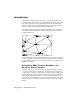
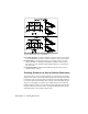
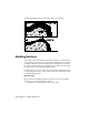
The triangles form a triangulated irregular network (TIN) surface. A TIN line is
one of the lines that makes up the surface triangulation, as shown in the
following illustration.
To create TIN lines, AutoCAD Land Desktop connects the surface points that
are closest together. These TIN lines interpolate surface elevations, filling in
the gaps where no survey data or contour data is known, to create an approx-
imation of the surface.
Using Point, DEM, Contour, Breakline, and
Boundary Data in Surfaces
Random point data, points taken at a variety of elevations and coordinates
as opposed to interpolated contour data, often makes the best surface data.
To use points for a surface, you can select point groups, select COGO points
from the drawing, or import point files. You can create point groups from the
points in the COGO point database. Point files can be ASCII text files or
Microsoft
®
Access database files. If you have blocks or lines at elevations in a
drawing, then their coordinates can also be selected as point data to use in
surfaces.