
Technical information


Performing Geodetic Transformations on Points | 61
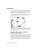
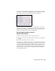
10 the Reference Point section, enter the grid northing and
grid easting coordinates for the first point that you
calculated with the Geodetic Calculator. Enter the local
northing and easting coordinates for the same point. Or,
if you already placed that point in the drawing, you can
click the Reference Point button and select the point from
the drawing. You can also enter the point number to
retrieve the local northing and easting coordinates.
11 Repeat step 10 using the second set of grid northing and
easting coordinates, but enter the information in the
Rotation Point section.
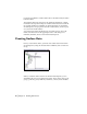
12 Click OK to apply the transformation settings.
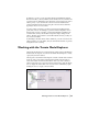
13 From the Points menu choose Point
Utilities
➤ Geodetic Calculator.
Now you can use the Geodetic Calculator to query the
grid northing/easting and latitude/longitude of any point
in the survey.
Using the Geodetic
Calculator
14 Enter the local northing and easting coordinates, and the
grid coordinates and latitude/longitude are calculated
automatically.
To calculate State Plane coordinates from GPS data (continued)
Steps
Use to locate