
Technical information


Performing Geodetic Transformations on Points | 59
In the following task, two separate GPS latitude/ longitude readings are taken
on two different points, and the local northing and easting readings of these
points are recorded.
To calculate State Plane coordinates from GPS data
Steps
Use to locate
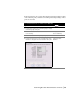
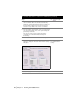
1 From the Projects menu, choose Drawing Setup to display
the Drawing Setup dialog box.
2 Click the Zone tab and select the current zone
for the drawing.
Changing the Current
Zone for a Drawing
3 Click OK to close the Drawing Setup dialog box.
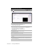
4 From the Points menu choose Point Utilities
➤ Geodetic
Calculator to display the Geodetic Calculator dialog box.
Using the Geodetic
Calculator