
Technical information

36 | Chapter 3 Working with COGO Points
Points and CAD Commands
The commands from the Points menu create COGO point objects that have
extended entity data. These objects are different from the simple CAD point
nodes that you can create with the POINT command.
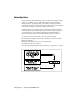
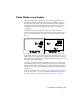
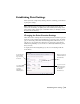
The following illustration shows a CAD point node created with the POINT
command on the left. On the right is a COGO point object created with a
command from the Points menu. The point text was dragged away from the
marker and a leader was created automatically.
The COGO points are usually assigned description and elevation data as well
as a required point number and northing and easting coordinates. This point
data is stored in the point database. In contrast, a point node exists only in
a drawing file, and it has only X, Y, and Z data associated with it.
You can convert CAD point nodes to COGO points by using the Convert
from AutoCAD Points command from the Points
➤ Point Utilities menu.
Working with the Project Point Database
AutoCAD Land Desktop uses a project point database to store the point infor-
mation for a project. This file is named points.mdb and is stored in the project
\cogo folder.
(For example, c:\Land Projects <Version Number>\newproj\cogo\points.mdb.)
You are prompted to set up this point database whenever you start a new
project.
The Points commands in AutoCAD Land Desktop, and any commands in the
civil engineering tools or surveying tools that create points, add points to a
point database. If you use the surveying tools to import a fieldbook file, then