
Technical information

Creating Existing Ground Cross Sections | 173
Key Concepts
■ You can plot sections that show existing ground conditions along the
roadway.
■ To create existing ground cross sections, you must define a road
alignment. A design profile, however, is not required until you apply a
template to the sections.
To generate existing ground cross sections
Steps Use to locate
1 From the Alignments menu, choose Set Current
Alignment to make sure that the proper alignment is set
as current.
Making an Alignment
Current
2 Generate existing ground section data using one of the
commands in the Cross Sections
➤ Existing Ground
menu.
The data can be extracted from a terrain model, from a
station/offset/elevation ASCII text file, or from manual
data entry.
Sampling the Existing
Ground Section Data from
One Surface
Creating the Existing
Ground Cross Section Data
From a Text File
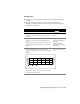
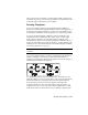
3 View the cross sections by selecting Cross
Sections
➤ View/Edit Sections. Cross sections are
displayed as temporary lines, as shown in the following
illustration.
Choosing Which Cross
Section Station to Edit or
View
Use the Next option to view the cross sections as they
progress along the alignment.