
Technical information

172 | Chapter 13 Viewing and Editing Roads in Section View
Creating Existing Ground Cross Sections
The first step in working with cross sections is to establish the existing
ground surface information. You can create the existing ground cross section
data in one of three ways:
■ Sample the data from one or more surfaces
■ Sample the data from a text file that contains station/offset/elevation data
■ Enter the data manually by using the Existing Ground Section Editor
As you sample the existing ground, elevational values for the cross sections
are created. If you sample multiple surfaces, then you must first create a file
of the surface names you want to sample using the Select Multiple Surfaces
command, and then you can use multiple surfaces for sampling by using the
Toggle Multiple Surfaces command.
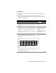
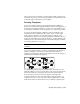
To control how the existing ground is sampled for cross section data, specify
the section sampling settings, such as how much of the existing ground is
sampled (the swath width), whether you are prompted to enter additional
stations to sample, and whether sample lines are imported onto the plan
view of the alignment. To specify sampling settings, choose Cross
Sections
➤ Existing Ground ➤ Sample From Surface. The Section Sampling
Settings dialog box is displayed, as shown in the following illustration.