
Technical information


Creating Existing Ground Profiles | 159
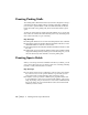
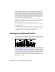
After you create the existing ground data for an alignment, you can generate
a profile. Create a full profile to define a finished ground alignment, or to
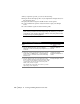
annotate the profile. A full profile, as shown in the following illustration,
includes a datum line, datum elevation, existing ground, existing ground
text, and grid base.
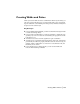
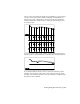
Or, you can create a quick profile, which is created without a horizontal or
vertical grid base or station elevations, as shown in the following illustration.
If you sampled multiple surfaces, then you can create subsurface profiles.
Usually you should create a full profile of the existing ground top surface,
and then create subsurface profiles for any other surfaces you sampled using
the Surface Profile command.