
Technical information

Using the Hydrology Calculators | 143
Data generated with the Water Drop command can help you visualize the
surface slopes and determine where water flows and accumulates during a
storm. You can use this information to decide the best way of controlling the
flow. After you’ve visualized the runoff paths on the surface, you can calcu-
late the peak runoff flow for different storm events.
Using the Hydrology Calculators
Many of the features in the Hydrology menu use calculator-type dialog boxes
to solve for an unknown value. For each calculator, you must enter the
known values in the appropriate field for the particular value, or use the
corresponding Select button to select the value from the drawing or from
another dialog box. You can select the unknown value that you want to
determine from a list at the top of the calculator. If you do not enter all
values, then the calculation is not completed.
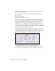
To add watershed and drainage data to the drawing
Steps Use to locate
1 Create an existing ground surface for the proposed site. Using the Terrain Model
Explorer
2 Generate watershed data for the existing ground surface
model.
Creating a Watershed
Model After Building the
Surface
3 From the Terrain menu, choose Surface Display
➤ Slope
Arrows to draw arrows that follow the slope of the existing
surface.
Drawing Arrows on a
Surface that Show Surface
Slopes
4 From the Terrain menu, choose Surface Utilities
➤ Water
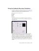
Drop to draw flow paths.
The Water Drop command traces the path of a drop of
water from the origin point to the point where it outflows.
This can help you determine where the major outflow
points are and where you may need to add hydraulic
structures.
Drawing Water Drop Paths
on the Current Surface