
Technical information

142 | Chapter 10 Hydrology and Hydraulics
Gathering Data for Hydrologic Analysis
As you evaluate a site to determine whether development is feasible, you
must consider what effect the development of the site has on area runoff. The
first step in this process is to gather hydrologic data about the site, primarily
for the pre-development model. To use the civil engineering tools for this,
you must have an existing ground surface, and you must know the soil types
and current land use of the site.
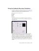
You can start a watershed hydrologic analysis by using the Terrain Model
Explorer, located in AutoCAD Land Desktop, to create an existing ground
surface model of the site. Then, you can use the watershed command (also
within the Terrain Model Explorer) to create polylines that outline principal
watershed areas on the surface model. Later, you can select these polylines
when you are prompted to choose a watershed area when using the
Hydrology commands. You can also add soil type information, including soil
boundary information, to the surface model.
Key Concepts
■ Before starting a hydrologic analysis of a site, determine the soil groups
existent at the site, the cover type, treatment, and hydrologic condition.
These features affect the results of the pre-development runoff
calculations.
■ A good way to start the hydrologic analysis of a site is to use the Terrain
Model Explorer to create a surface model, complete with topographical
information, watershed boundaries, subarea flow paths, slope arrows, and
relevant hydrologic data.
■ The compiled topographic and hydrologic data should extend sufficiently
off-site to provide adequate coverage of the drainage area affected by the
proposed development.