
Technical information


Exporting Data in LandXML Format | 113
Exporting Data in LandXML Format
Using the LandXML Export command, you can export the following
LandXML data from an AutoCAD Land Desktop project:
■ COGO points
■ Point groups
■ Description keys
■ Surfaces
■ Parcels
■ Alignments
■ Profiles
■ Cross sections
■ Interactive Highway Safety Design Model (IHSDM) data
■ Pipe runs
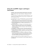
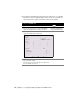
The following illustration shows the LandXML Export dialog box, which you
can access by choosing Export LandXML from the Projects menu. Use the
options in this dialog box to select the data to export and to specify Export
Options and Point Reference settings.
Key Concepts
■ When you select the points to export, you can also choose to export the
point groups and description key definitions.
■ When you select the surfaces to export, you can also choose to export the
watershed definitions.