
Technical information


92 | Chapter 5 Working with Alignments and Parcels
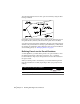
Working with Parcels
When you create base maps or work with subdivisions, you must define
parcels of land. You can define parcels from survey figures, points, lines,
curves, or polylines. Parcel boundaries define the area and the limits of each
parcel. If you define parcels by area, then you can use the Parcel Sizing
commands to create parcels of exact areas.
Like alignments, parcel definitions are stored in an external database so mul-
tiple people can access them. Because parcel definitions are stored externally,
you can delete the geometry in the drawing and still reference the parcel.
When defining parcels, you can label them with a parcel number, area, and
description. To manage parcels, use the Parcel Manager command from the
Parcels menu. You can use this command to report map check and inverse
data, as well as to import, delete, and rename parcels.
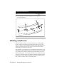
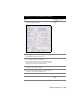
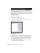
9 From the Alignments menu, choose Create Station Labels
to create station labels. The labels are displayed as shown
in the following illustration.
Creating Station Labels on
an Alignment
To draft road results (continued)
Steps
Use to locate