
2008


Terrain
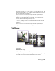
Using contours to build a terrain
Creates
terrain objects on page 703 from contour line data. You select editable
splines representing elevation contours and 3ds Max creates a mesh surface
over the contours. You can also create a "terraced" representation of the terrain
object so that each level of contour data is a step, resembling traditional study
models of land forms.
When you import an AutoCAD drawing file to use as contour data, 3ds Max
names each object based on the AutoCAD object's layer, color, or object type.
3ds Max appends a number after each name. For example, an AutoCAD object
on the layer BASE becomes BASE.01.
Glossary | 7947