
2008


NOTE DEM and DDF files do not contain Alignment data.
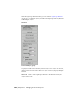
■ Parcels 2D legal parcel or lot boundaries. Parcel data is imported to 3ds
Max as a Shape object.
NOTE DEM and DDF files do not contain Parcel data.
NOTE 2D Alignment and Parcel shapes are created on top of the highest terrain
surface.
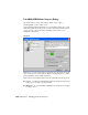
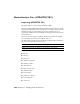
File Data group
The File Data group displays information about the file to be imported,
including date of creation, author, the application used to create the file, and
the units.
Object Creation Options group
The Object Creation Options group lets you set the import properties for
selected objects.
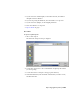
Color The color of the object when it is imported into 3ds Max. To change
this setting, click the color swatch and select a new color from the Color
Selector.
Smooth Surface Applies smoothing to the geometry, based on the Smoothing
Angle setting. Edges between faces that have an angle between them that is
greater than the specified smoothing angle will appear faceted in the scene.
Edges between faces that are below or equal to the specified angle are
smoothed.
NOTE This option is only available for terrain surface objects.
Smoothing Angle Determines the size of the smoothing angle.
NOTE This option is only available for terrain surface objects.
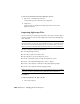
Model Creation Options group
Set Scene Units from file Changes the 3ds Max Scene Unit to match the
units of the incoming file.
LandXML (XML, DEM) Files | 7047