
2008

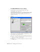


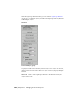

LandXML/DEM Model Import Dialog
File menu > Import > Select File to Import dialog > Files of Type >
LandXML/DEM (*.DEM, *.XML, *.DDF)
In the LandXML/DEM Model Generator, you determine which parts of your
land development data are imported to 3ds Max. 3ds Max then creates separate
objects for each of the land features, including terrain surfaces, road
alignments, and parcels.
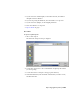
Interface
Object List Lists the terrain surfaces, alignment data, and parcel data in the
file to be imported. You can toggle the import of individual objects or entire
groups with their corresponding check boxes.
Three types of civil engineering data stored in LandXML files are supported:
■ Surfaces 3D TIN ground and finished surface model. Terrain surface data
is imported to 3ds Max as an editable mesh.
■ Alignments 2D road centerlines. Alignment data is imported to 3ds Max
as a Shape object.
7046 | Chapter 21 Managing Scenes and Projects