
2008

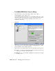


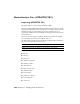

The LandXML/DEM Model Import dialog on page 7046 allows for
interoperability with Autodesk products such as Land Development Desktop
3, Land Development Desktop 2005, Civil 3D
™
, and CAiCE Visual PE. Once
imported, the models are ready for high-quality photorealistic rendering and
animations.
LandXML File Types
There are three file types you can import with the LandXML/DEM Model
Import dialog: XML, DEM, and DDF.
■ XML is the most robust file type for LandXML import. In addition to surface
elevation data, XML files can also contain Alignment (road) and Parcel
data.
■ The DEM (digital elevation model) file type is the most commonly available
large area surface data type supplied by the USGS and other government
and private organizations. DEM files contain only surface data.
■ The DDF file type is an SDTS (spatial data transfer standard) format grid
surface. DDF files are very similar to DEM files; however, DDF information
is shared across multiple files.
The LandXML/DEM Model Import utility searches for the key DDF file in
the selected directory, which is identified by the following pattern: xxxxCEzz,
where xxxx is usually numeric and zz typically 'L0'.
Like DEM files, DDF files only contain surface data.
LandXML (XML, DEM) Files | 7045