
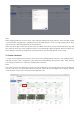
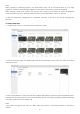
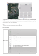
User manual
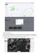
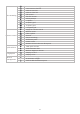

Home point
vertical landing height
The drone position is
the home point
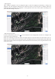
waypoint coordinates
×
×
×
50~1000 m
When turned on, the
drone will return to the
take-off position; when
turned off, the home
point is the home point
latitude and longitude
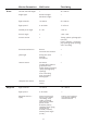
Waypoint Action -
Hover
Waypoint Action -
Circling
Associated
observation points
waypoint
coordinates
Gimbal pitch angle
Pan tilt angle
Camera action (no
action, video
recording, photo
taking, timed photo
taking)
Heading when flying
(along route,
manual, custom)
Gimbal pitch angle
(0~90°)
×
support
latitude and
longitude
×
×
×
Radius (10~500 m)
Number of laps (1~99)
support
latitude and longitude
-120~0°
-180~180°
Circle up point
flight altitude
Hover radius
waypoint coordinates
×
×
×
50~1000 m
100~500 m
latitude and longitude
Circle down
point
flight altitude
Hover radius
waypoint coordinates
×
×
×
50~1000 m
100~500 m
latitude and longitude
View point
association
Action radius
waypoint coordinates
Elevation correction
Associate Waypoint
×
latitude and longitude
×
Associated segment
100~500 m
latitude and longitude
DEM correction
Manual correction