Autel Skycommand Center User Manual
Disclaimer And Warning Thank you for your interest in products provided by Autel Robotics Co., Ltd (hereinafter referred to as “Autel Robotics”). Please read the following terms carefully and acknowledge that you have understood and agreed the following terms, conditions and safe operation guide. This Manual will update without a fixed schedule. In order to ensure your use of the latest version, please visit: www.autelrobotics.
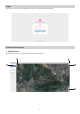
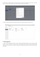
Log in Enter your account and password to log in to Autel Command Center. Interface Description 1. Flight Mission Display the location of pilot, device and mission status.
1. Navigation bar Show/Hide Menu: flight mission, flight schedule, mission management, fleet management, team management, general settings. 2. Device list Display real-time status of in-process missions, online aircrafts, online pilots, online nests, and focus on selected objects. Note: If there’s a device which is performing the system mission, then it will display the route of the mission; if no device performing the mission, then it will display the trailing track. 3.
1. Calendar style Displays by month or week. Click on a mission in the calendar to view the mission details. 2. List style Contains information like mission name, mission ID, creation date, execution team, execution pilot, start time, total mileage, total duration, and operations. Note: Immediate execution-type missions will not be displayed in the "Flight Plan." If the mission is created but not issued, it will not be displayed in the "Flight Plan." 3. Mission Management 1.
4. Fleet Management Add or edit devices (including aircrafts and Nests), reset Nest passwords, and view the device's flight times, last flight date, flight duration, and other information. Note: Log in with an organization account to view all devices under the organization; log in with a team account, view all devices under the team. 1. Search box Enter the device name or serial number to search for the corresponding device. 2.
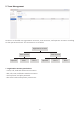
5. Team Management Accounts are divided into organization accounts, team accounts, and operator accounts according to their permission levels. The construction is as below. Organization account Team account Operator Pilot 1 Team account Operator Pilot 1 1.
Organization account Permissions Team leader Operator Add device √ x Edit device √ x View device √ √ Add new member √ x Edit member √ x View member √ √ Flight control authority settings x √ Live authority x √ Create mission x √ View mission x √ Edit mission x √ View flight log x √ Edit light log x √ 2. Team account permissions · Support adding, editing, viewing and deleting member accounts · Support reset operator and pilot password 3.
6. General Settings 1. Gear Setting The default value is 1, and the range is 1-10. The larger the value, the greater the range of the stick during remote control. 2. Language switch Select the system language as Simplified Chinese or English. 3. Map switch Select the system map as AMap or Google Map. Operation Note: It is necessary to ensure the smooth operation of the operator's network throughout the process. In following operation instructions, we use the organization account as an example. 1.
2. Switch to the member page, click Add member, and edit the member's name, team, role (team leader, operator, pilot), login account and password in the pop-up window. 3. Switch to the role page and assign permissions according to different member roles. 2. Add equipment 1. Log in to the organization account, enter the fleet management page, you can choose to add a drone or a Nest, and enter the device name, serial number, and team in the pop-up window.
Note: When adding a Nest for the first time, enter the Nest name and serial number. After the Nest model is automatically recognized, a password input field will appear. Enter a 6-digit password for Nest authentication, and the password can be modified.
2. Mission configuration · Configure route parameters You can configure route parameters first and then add waypoints. You can also click to add waypoints directly on the map; if you configure route parameters first and then add waypoints, the flight altitude of the generated waypoints defaults to the flight altitude in the route configuration. It is the reference base; when no waypoints are added, only waypoints can be added first.
· Add waypoint After adding a waypoint, click the waypoint again to edit the waypoint parameters or delete the waypoint. The last waypoint added by the multi-rotor device is the end point by default. While the fixed-wing device generates the waypoint, it also generates the route, return point, ascending circle point and descending circle point. · Add observation points Click the observation point icon ( ) at the bottom of the configuration interface to configure the observation point parameters.
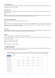
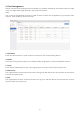
Route Waypoint Mission Parameters Multi-rotor Fixed-wing vertical take-off height × 45~1000 m height type Relative height Absolute height × flight altitude 10~800 m 50~1000 m flight speed 4~36 km/h 17~25 m/s Gimbal pitch angle 0°~90° -120°~0° Pan tilt angle × -180°~180° mission action × Timing photo (photograph interval) Fixed distance photography (photography spacing) start recording Disconnected action Return Continue the mission × yaw angle Along the route Manual Customize ×
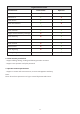
Waypoint Action Hover Camera action (no action, video recording, photo taking, timed photo taking) Heading when flying (along route, manual, custom) Gimbal pitch angle (0~90°) × × Radius (10~500 m) Number of laps (1~99) Associated observation points support support waypoint coordinates latitude and longitude latitude and longitude Gimbal pitch angle × -120~0° Pan tilt angle × -180~180° vertical landing height × 50~1000 m The drone position is the home point × When turned on, the drone w
Note: When creating a fixed-wing mission, one observation point can be associated with up to 5 flight segments, and the associated flight segments of two observation points cannot be repeated. When creating a multi-rotor mission, you can only add 1 camera action when you select the waypoint action and select "fly over". Multiple camera actions can be added when "Hover" is selected. 3. After the parameter configuration is completed, click Save to return to the mission management interface. 4. Issue missions 1.
5. Perform missions 1. Pilots can log in with the username and password created by the command center on the app side, and can view the system missions issued by the command center. 2. Click the mission card to enter the mission details page, and click the take-off button to start the mission. Note: The pilot can download the missions issued by the command center to the local. If there is a newly assigned mission, the App will receive a notification and prompt again 10 minutes before the mission starts.
2. When the pilot receives the application notification on the App, the pilot can choose to accept or reject the application. 3. The command center can only remotely control one aircraft at the same time. When one account is performing remote control, other accounts can no longer apply for the control right. Note: If the object applying for control in the background is the Autel Dragonfish fixed-wing UAV, the pilot must first set the ground station gear to A before transferring the control right. 4.
2. Click on the map to generate a quick mission point. The quick mission point can be dragged and dropped with the mouse, and the mission parameters can be edited in the pop-up parameter configuration bar. 3. After editing, click "Go", the system will prompt whether to suspend the current mission, click "OK", the device will fly to the quick mission point. Note: To return to the previous route mission, click the ( ) icon.
Live streaming Remote control Quick mission Flight plan Mission management Live screen to the right Live screen to the left Click to start live Click to close live Full screen Exit Full Screen Alarm prompt 1 Square 4 Square grid 9 Square grid 16 Square grid Apply for remote control Back to home Take a photo Record Pause recording Reference point Center route Remote control shortcut description New quick mission View elevation data Back to waypoint mission Display in card Display in list Mission renaming
©2022 Autel Robotics Co., Ltd. All Rights Reserved www.autelrobotics.