
Manual
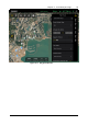
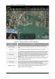
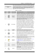
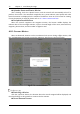
Table Of Contents
- Chapter 1 Aircraft
- Chapter 2 Remote Controller
- Chapter 3 Smart Battery
- Chapter 4 Autel Enterprise App
- Chapter 5 First Flight
- 5.1 Instructions for First Flight
- 5.2 Flight Precautions
- 5.3 Pre-Flight Preparations
- 5.3.1 Unpacking
- 5.3.2 Charging
- 5.3.3 Preparing the Aircraft
- 5.3.4 Installing/Removing Propellers
- 5.3.5 Preparing the Remote Controller
- 5.3.6 Login, Pairing, Activation (activation only upon first use)
- 5.3.7 Novice Guide (first time use only)
- 5.3.8 Reconnect the aircraft (not required by default, required after disconnection)
- 5.4 Pre-Flight Inspection
- 5.5 Basic Flight Process
- Chapter 6 Firmware Update and Maintenance
- Appendix A Product Specifications

66 Chapter 4 Autel Enterprise App
EVO Max 4T User Manual
searched.
9
Map
Management
Click this button to adjust the map style to a standard
map or a hybrid map and also support setting
display/clear flight tracks.
Standard map: 2D map.
Hybrid map: Satellite and 2D map combined.
10
Orientation
Lock
When the remote controller is rotated, the position of
the map will change accordingly. Click this button to
lock the direction of the map of the current remote
controller.
11
Position
Click this button, and a dialog box will pop up, and you
can choose to locate the remote controller location, the
home point location, the aircraft location, and view the
entire route.
12
Re-center
If the map is moved from the current positioning point
to another location, this button will appear on the right,
click this button, and the map will quickly return to the
current positioning point.
13
Pause
When executing a mission, click this button, and the
aircraft will hover at the current position.
14
End
Click this button, and the aircraft will return home
automatically.
15
Edit Route Click this button to edit the route settings.
Add a Waypoint
Click the "Waypoint Setting" button, find the starting point on the map and click it to create
the first waypoint, and then repeat the previous operation to create multiple waypoints as
required.
Set Route and Waypoint Parameters
During the process of adding a waypoint, a waypoint setting dialog box will pop up on the
right, where you can set the corresponding parameters and actions of the aircraft at this point.
At the same time, after the entire route is generated, click on the far right column to set the
route and each waypoint.
Set route mission Name and Route Altitude
Click the "Route Mission Name" edit box and enter the Name as required. Then click the
drop-down list of "Route Altitude Type" and select Relative Altitude or Altitude.
Set Flight Altitude
Refers to the altitude relative to the home point when the aircraft flies to this waypoint. In
the "Flight Altitude" edit box, directly enter the flight altitude value or click the buttons to
adjust.