
Manual
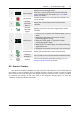
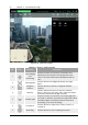
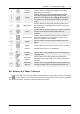
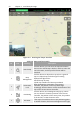
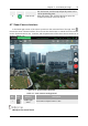
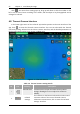
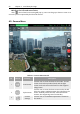
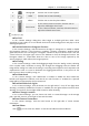
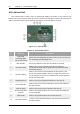
Table Of Contents
- Chapter 1 Aircraft
- Chapter 2 Remote Controller
- Chapter 3 Smart Battery
- Chapter 4 Autel Enterprise App
- Chapter 5 First Flight
- 5.1 Instructions for First Flight
- 5.2 Flight Precautions
- 5.3 Pre-Flight Preparations
- 5.3.1 Unpacking
- 5.3.2 Charging
- 5.3.3 Preparing the Aircraft
- 5.3.4 Installing/Removing Propellers
- 5.3.5 Preparing the Remote Controller
- 5.3.6 Login, Pairing, Activation (activation only upon first use)
- 5.3.7 Novice Guide (first time use only)
- 5.3.8 Reconnect the aircraft (not required by default, required after disconnection)
- 5.4 Pre-Flight Inspection
- 5.5 Basic Flight Process
- Chapter 6 Firmware Update and Maintenance
- Appendix A Product Specifications

54 Chapter 4 Autel Enterprise App
EVO Max 4T User Manual
Figure 4-11 Entering the "Maps" interface
Table 4-6 Maps Interface Details
No. Icon Meaning Description
1
Search Map
Click this button, you can enter the required location
Name in the "Search Map" edit box, and then select the
correct location, and the specific location will be
searched.
2
Map
Management
Click this button to adjust the map style to a general
map or a hybrid map, and also support setting
display/clear flight tracks.
Standard map: 2D map.
Hybrid map: Satellite and 2D map combined.
3
Orientation
Lock
When changing the orientation of the remote
controller, the position of the map will change
accordingly. Click this button to lock the direction of the
map of the current remote controller.
4
Positioning
Click this button, and a dialog box will pop up, where
you can choose to locate the position of the remote
controller, the position of the return point, the position
of the aircraft, or view the entire route.
5
Re-center
If the map is moved from the current positioning point
to another location, this button will appear on the right,