
User manual
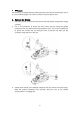
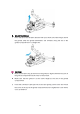

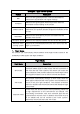


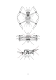
Table Of Contents

28
Important
The aircraft will record the takeoff point as the default home point. The accurate
landing only takes effect when the home point is not updated during flight.
Select an open area with sufficient light as the takeoff point.
To use this feature, make sure that the environment where the aircraft takes off
is not changed.
Landing protection and accurate landing features can be enabled using the
App.
2.1.7 Omnidirectional Binocular Vision Sensing System
The binocular vision sensing systems on the front, rear, left, right, top, and bottom of
the EVO II RTK Series V3 aircraft use image data to calculate the distance between
the aircraft and potential obstacles. Once an obstacle is detected, the system will
stop the aircraft from flying forwards. The binocular vision systems on the front, rear,
and bottom are also equipped with a Starpoint positioning system. This system uses
the ultrasonic sensor to calculate the altitude of the aircraft and is combined with the
binocular vision camera to obtain the location information through image analysis.
Binocular vision sensing system
System
Position on the Aircraft
Obstacle Sensing Range
Front
Front of the aircraft
0.5 to 18 m
Rear
Tail of the aircraft
0.5 to 16 m
Left/Right
Rear part on the left and right
sides of the aircraft
0.5 to 10 m
Top
Top of the aircraft
0.5 to 10 m
Bottom
Bottom of the aircraft
0.5 to 10 m
The figure below shows the covering angle of each binocular vision sensing system: