
EVO Nano Series User Manual
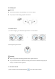
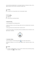

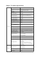
Table Of Contents
- User Manual
- EVO Nano Series
- Terms for Usage
- Trademark Information
- Copyright
- Disclaimer
- Data Storage and Use
- Table of contents
- Chapter 1 Read Instructions
- Chapter 2 Aircraft
- ① Propeller
- ④ Forward visual system
- ② Motor
- ⑤ Antenna
- ③ PTZ camera
- ⑥ Rear vision system
- ⑨ USB-C port
- ⑦ Power button
- ⑩ Rear LED indicator
- ⑧ Aircraft battery
- ⑪ SD card slot
- ⑫ Air outlet
- ⑬ Ultrasonic sensor
- ⑮ Air inlet
- ⑭ Downward vision system
- There is an LED indicator on the tail of the aircr
- Status Definition of Flight LED Indicator
- Back LED Indicator
- Meaning
- Normal status
- Green light flashes slowly (1 flash every 2 second
- Aircraft in GPS mode
- Yellow light flashes slowly (1 flash per second)
- Aircraft in ATTI mode
- Pairing
- Green light flashes quickly
- Aircraft and remote controller are pairing
- Green light stays on for 5 seconds
- Pairing successful
- Red light stays on for 5 seconds
- Pairing failed
- Compass calibration
- Yellow light is on
- Starting compass calibration
- Yellow light is on
- Calibration failed
- Green light is on
- Calibration successful
- Warning
- Yellow light flashes slowly (1 flash per second)
- Low battery warning
- Red light flashes slowly (1 flash per second)
- Critical low battery alert
- Updating
- Green light flashes quickly
- Aircraft is updating
- Green light is is on
- Update successful
- Yellow light flashes slowly (1 flash per second)
- Update failed
- The battery for EVO Nano is 2250mAh and has the ra
- The battery indicator is divided into LED 1, LED 2
- Chapter 3 Remote controller
- Chapter 4 Autel Sky App
- Chapter 5 Flight
- 1) As shown in figure, press the left and right st
- 2) Slowly push up the left stick.
- 1) Press and slide the one-click takeoff button (
- 2) The aircraft will automatically rise to the hei
- Class I: main airport & low-altitude area for mann
- Class II: Sensitive area or organization & militar
- Chapter 6 Maintenance and service
- Method 1: download firmware upgrade package from A
- Method 2: download firmware upgrade package from t
- Chapter 7 Technical Specification

A circular area centered on this area and with a radius of 1km
2. Warning area
APP will give a warning information when the aircraft enters the area of 2km from the
airport.
5.4.2 Height limit and distance limit
The maximum height is used to restrict the flight height of the aircraft, and the maximum
radius is used to restrict its flight distance. User can make settings in Autel Sky App. In the
case of valid GPS, the flight restriction and the height and distance limits in special area will
jointly affect the flight. In the case of invalid GPS, the aircraft will be restricted only by
height.
Remark
The flight height refers to the vertical height of the aircraft above the return point, and
the flight distance refers to the horizontal distance between the aircraft and the return
point.
The flight height is 120m by default, with the adjusting interval of 30~800m; the
maximum distance is at least 30m by default, with the adjusting interval of 30 and above;
the return height is 30m by default, with the adjusting interval of 30~800m. The flight
height, maximum distance and return height are the system default, which can be
adjusted by user as required.
Under the beginner mode, the default values are 30m for flight height, 100 for maximum
distance, 30m for return height and 11km/h for maximum flight speed, and the modes
cannot be switched.
The height limits are different in each country and region. Please the local air traffic
management authority for actual height limit.