
EVO Nano Series User Manual

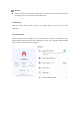
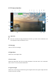
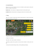
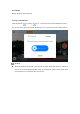
Table Of Contents
- User Manual
- EVO Nano Series
- Terms for Usage
- Trademark Information
- Copyright
- Disclaimer
- Data Storage and Use
- Table of contents
- Chapter 1 Read Instructions
- Chapter 2 Aircraft
- ① Propeller
- ④ Forward visual system
- ② Motor
- ⑤ Antenna
- ③ PTZ camera
- ⑥ Rear vision system
- ⑨ USB-C port
- ⑦ Power button
- ⑩ Rear LED indicator
- ⑧ Aircraft battery
- ⑪ SD card slot
- ⑫ Air outlet
- ⑬ Ultrasonic sensor
- ⑮ Air inlet
- ⑭ Downward vision system
- There is an LED indicator on the tail of the aircr
- Status Definition of Flight LED Indicator
- Back LED Indicator
- Meaning
- Normal status
- Green light flashes slowly (1 flash every 2 second
- Aircraft in GPS mode
- Yellow light flashes slowly (1 flash per second)
- Aircraft in ATTI mode
- Pairing
- Green light flashes quickly
- Aircraft and remote controller are pairing
- Green light stays on for 5 seconds
- Pairing successful
- Red light stays on for 5 seconds
- Pairing failed
- Compass calibration
- Yellow light is on
- Starting compass calibration
- Yellow light is on
- Calibration failed
- Green light is on
- Calibration successful
- Warning
- Yellow light flashes slowly (1 flash per second)
- Low battery warning
- Red light flashes slowly (1 flash per second)
- Critical low battery alert
- Updating
- Green light flashes quickly
- Aircraft is updating
- Green light is is on
- Update successful
- Yellow light flashes slowly (1 flash per second)
- Update failed
- The battery for EVO Nano is 2250mAh and has the ra
- The battery indicator is divided into LED 1, LED 2
- Chapter 3 Remote controller
- Chapter 4 Autel Sky App
- Chapter 5 Flight
- 1) As shown in figure, press the left and right st
- 2) Slowly push up the left stick.
- 1) Press and slide the one-click takeoff button (
- 2) The aircraft will automatically rise to the hei
- Class I: main airport & low-altitude area for mann
- Class II: Sensitive area or organization & militar
- Chapter 6 Maintenance and service
- Method 1: download firmware upgrade package from A
- Method 2: download firmware upgrade package from t
- Chapter 7 Technical Specification

16. Attitude Indicator
Display the current aircraft position, aircraft nose orientation, operator position, home point
position, and flight status parameters.
H 800m 34m/s: Vertical distance and flight speed between aircraft and home point.
D 10000m 34m/s: Horizontal distance and flight speed between aircraft and home point.
17. Map
Click once to indicate the small map. Click the small map again to switch from the image
transmission interface to the large map.
- No-fly zone reminder: view the information on no-fly zone: height limit zone, etc.
- Compass: see orientation.
- Map mode: select normal, satellite, or blend layer.
- Positioning: quickly lock the position of aircraft, remote controller, or home point on the
map.
- Find my drone: find the missing aircraft by activating flashing and beeping.