
Technical data


Survey Preparation & Execution 35
Surveying
Now that the base and rover systems are configured, point location can begin.
Using the rover system, you will move about the project area collecting data on
points of interest in order to determine their position. This process involves two
primary functions that you must execute repeatedly. These functions are
Initialization and Point Observation. Let’s discuss each of these functions below:
Kinematic Initialization
Priortoperforminganyfeaturelocationwiththeroversystem,itmustfirstgothrough
an initialization process. The initialization process is required to produce highly
precise positions. Prior to initialization, the rover system will compute positions at
a degraded level of accuracy. The accuracy prior to initialization could be anywhere
from 0.15 meters (0.5 ft) to a couple meters (several feet). The initialization process
is required to fine-tune the rover system. Once initialized, the rover system will
function at its specificed level of accuracy until initialization is lost.
Let’s devote a few sentences here to the technical aspects of the initialization
process. In order to accomplish centimeter-level positioning with GPS, you must
collect enough data to calculate a set of parameters termed integer ambiguities.
During the initialization process, you are collecting the data required to calculate
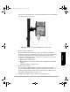
Figure 4.8. Rover System Ready to Survey
630045.book Page 35 Sunday, February 11, 2001 11:38 AM