
Specifications


172 Z-Family Technical Reference Manual
The altitude is either ellipsoidal (default) or geoidal (mean-sea-level) depending on the selection
made with $PASHS,HGT. The Geoidal separation when subtracted from the ellipsoidal altitude
gives the geoidal altitude.
Example:
Query: $PASHQ,POS <enter>
Response:
$PASHR,POS,0,06,214619.50,3722.385158,N,12159.833768,W,00043.1
10,,331.0,000.7,000.0,02.7,01.2,02.4,01.6,UC00*6C <enter>
m3 Current UTC time of position fix (hhmmss.ss) 00-235959.90
m4 Latitude component of position in degrees and decimal minutes
(ddmm.mmmmmm)
0 - 90
c5 Latitude sector, N = North, S = South N/S
m6 Longitude component of position in degrees and decimal
minutes (dddmm.mmmmmm) 0 - 180
c7 Longitude sector E = East, W = West W/E
f8 Altitude above whatever datum has been selected in meters. For
2-D position computation this item contains the altitude held
fixed.
±30000.000
f9 reserved
f10 True track/course over ground in degrees 0 - 359.9
f11 Speed over ground in knots 0 - 999.9
f12 Vertical velocity in decimeters per second
±999.9
f13 PDOP - position dilution of precision, 0 - 99.9
f14 HDOP - horizontal dilution of precision. 0 - 99.9
f15 VDOP - vertical dilution of precision. 0 - 99.9
f16 TDOP - time dilution of precision. 0 - 99.9
s17 Firmware version ID 4 char string
*cc checksum
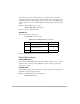
Table 6.106: POS Message Structure (continued)
Parameters Description Range