
User`s guide


11
Saving an underwater position to memory
One of the most useful features of NavDive is the ability to save your current GPS position
(latitude and longitude) whenever you find something underwater that is noteworthy. This
could be a wreck, a training platform, geologic feature, or maybe just an interesting part of the
reef.
To save your current position with NavDive, follow the steps below:
1) Get as close as possible to the item/area you want to capture. Then make sure the
cable is taut and that your flag float is directly overhead.
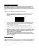
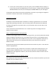
2) From the HOME SCREEN, press the DOWN switch once. You should then see the
following:
Save Position:
Cancel
3) To cancel the SAVE POSITION operation, you can simply press the ENTER switch when
the CANCEL option is displayed on the LCD. NavDive will then return to the HOME
SCREEN without saving your position.
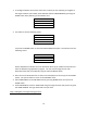
4) To save your position, press the RIGHT switch to scroll through the available
descriptions that you can select to designate the position to be saved. NavDive is
preloaded with a number of useful tags (i.e. small wreck, large wreck, platform,
geologic, etc.). The last selection in the list is OTHER, which can be used if none of the
other tags are appropriate.
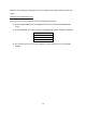
5) Once you have selected the proper tag and it is displayed on the LCD, press the ENTER
switch. The LCD will then briefly display POSITION SAVED on the LCD and the system
will automatically return to the HOME SCREEN.
6) NavDive will create a record on the SD Card for this position in the file for this dive
under the SAVED POSITIONS folder. The record will contain the date/time, description
tag, and lat/long position.
Using the Tracking feature
NavDive contains a useful feature called “tracking” that, once enabled, automatically saves your
GPS position to memory every 10 seconds during the dive. The captured information can then
be used to create a “trace” of the path you swam during the dive – useful for documenting
search patterns, courses followed, etc.